Project Benefits
The One Earth Sequestration (OES) project delivers meaningful environmental, economic, and community benefits while advancing Illinois’ leadership in clean fuel innovation. This page outlines both the value of the project and the work underway to safely develop and operate the proposed carbon storage system.
Environmental Benefits
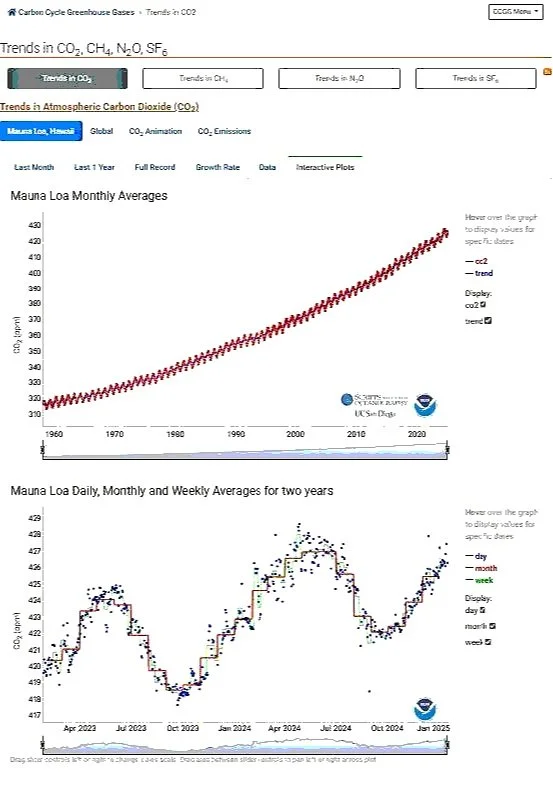
Greenhouse gases (GHGs) trap heat in the atmosphere, contributing to climate change. The natural greenhouse effect is essential for life on Earth, but the enhanced greenhouse effect — driven by human activities — is causing global warming.
The National Oceanic and Atmospheric Administration (NOAA Global Monitoring Laboratory) monitors long‑term climate drivers, including CO₂, CH₄, N₂O, and CO. Atmospheric CO₂ concentrations continue to rise, as shown by NOAA’s Mauna Loa Observatory dataset.
Capturing CO₂ from ethanol fermentation prevents these emissions from entering the atmosphere. Because fermentation CO₂ is already part of the natural carbon cycle, capturing and storing it deep underground provides an immediate climate benefit.
One Earth Sequestration proposes to capture 521,000 metric tons of CO₂ annually — the equivalent of removing 123,999 gasoline‑powered vehicles from the road for one year, nearly all vehicles registered in McLean County, Illinois.
Clean Fuel Innovation
The project supports the growing market for low-carbon fuels, including sustainable aviation fuel (SAF) and other e-fuels that rely on captured CO₂ as a feedstock.
Captured CO₂ can be used to produce cleaner fuels when paired with green hydrogen.
Lower-carbon ethanol and e-fuel production strengthen Illinois’ leadership in renewable energy and agricultural innovation.
These fuels help reduce global emissions from transportation and industry.
Agricultural Benefits
Illinois farmers benefit directly from a stronger, more competitive ethanol sector.
Supports long-term demand for locally grown corn.
Helps ethanol producers meet low-carbon fuel standards, keeping Illinois agriculture competitive in national and international markets.
Strengthens rural economies by supporting jobs, local services, and energy independence.
Economic Benefits
The project brings significant economic activity to the region through construction, operations, and long-term monitoring.
Local and regional job creation during construction and operations.
Increased spending on goods, services, and local businesses.
New tax revenue that supports schools, infrastructure, and community services.
Long-term investment in Illinois’ clean-energy economy.
The One Earth Sequestration (OES) project supports local communities and strengthens Illinois’ clean‑energy economy. Construction, operations, and long‑term monitoring activities generate new jobs, increase local spending, and contribute tax revenue that supports schools, infrastructure, and essential public services.
Regional Economic Impact (2007–2024) Independent economic analyses of One Earth Energy’s operations show substantial benefits across multiple counties:
Ford County
$5.6 billion total economic impact
$1 billion in labor income
12,000+ full‑time equivalent jobs supported
McLean County
$1.6 billion estimated economic impact
5,000+ full‑time equivalent jobs supported
Statewide Impact
$10.7 billion total economic impact from 2007–2024
$6.8 billion projected additional impact from sustainable aviation fuel (SAF) production
$1.5 billion in labor income
2,000+ new full‑time equivalent jobs
$256 million in county and state tax revenue
PLANNED PROJECT ACTIVITIES
Geologic Setting for Safe, Permanent CO₂ Storage
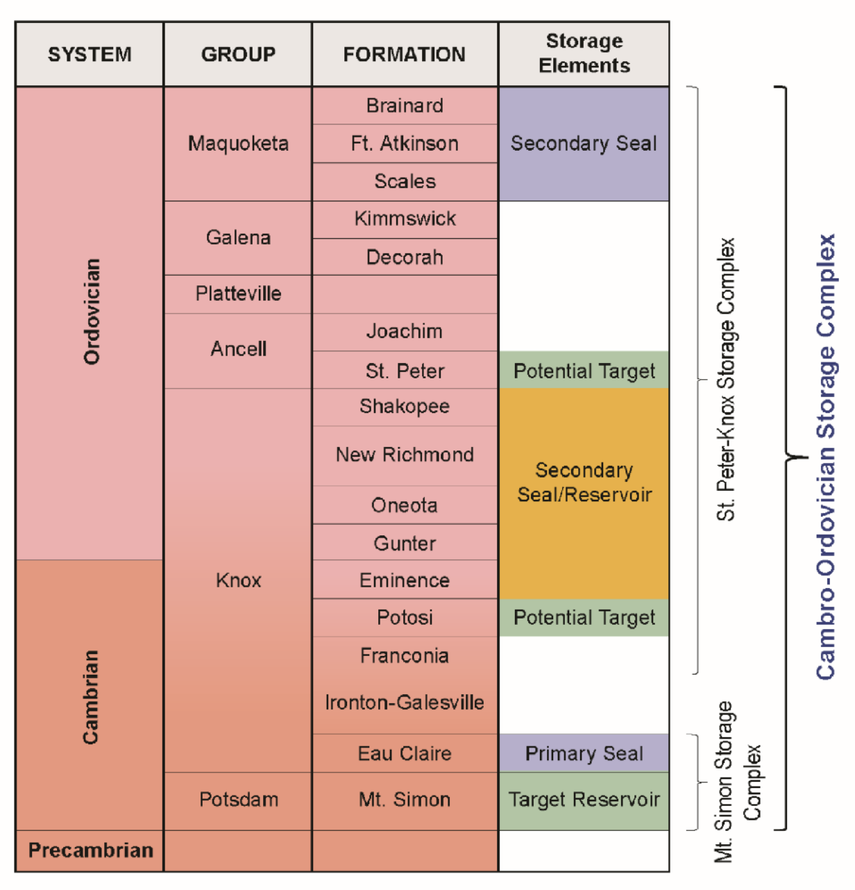
This region of Illinois contains some of the most suitable geology in the Midwest for long‑term carbon storage. The project will store CO₂ deep underground in the Mt. Simon Sandstone, a thick and well‑characterized sandstone reservoir more than a mile below the surface. The formation has suitable porosity and permeability to accept injected CO₂ and store it safely within the rock.
Directly above the Mt. Simon lies the Eau Claire Formation, a dense, regionally extensive shale and siltstone unit that serves as the primary confining layer. Its low permeability and lateral continuity make it one of the most reliable geologic seals in the Illinois Basin, and it has been successfully used for decades to contain natural gas and CO₂ in other parts of the state.
The St. Peter Sandstone, located thousands of feet above the injection interval, is the lowermost underground source of drinking water (USDW) in this area. It is monitored as part of the project’s groundwater monitoring plan, along with deeper monitoring intervals in the Ironton‑Galesville Formation and the Mt. Simon Sandstone itself.
Above the St. Peter, the Maquoketa Shale and New Albany Shale form thick, laterally continuous shale units that act as additional confining layers. Between the injection interval and the lowermost USDW lie multiple regional shale formations and thousands of feet of low‑permeability rock, creating a robust, multi‑layer geologic barrier that reinforces long‑term storage security.
Extensive characterization by state and federal agencies has confirmed the suitability of these formations for permanent CO₂ storage. The combination of a deep sandstone reservoir, a proven primary seal, and multiple overlying shale units makes this part of Illinois an excellent location for safe, long‑term carbon sequestration.
Monitoring and Verification
The project will use a comprehensive monitoring system to track CO₂ movement and verify long‑term storage performance. Monitoring includes:
Deep subsurface monitoring in the Mt. Simon and Ironton‑Galesville formations
Groundwater monitoring in the St. Peter Sandstone, the lowermost USDW
Continuous pressure and injection monitoring at the well
Periodic geophysical surveys to confirm CO₂ remains within the intended storage zone
These activities ensure that the CO₂ remains within the deep geologic system and that all project operations meet federal Class VI requirements.
Long‑Term Stewardship
After injection ends, the project will continue monitoring the site until federal regulators confirm that the CO₂ remains stable and securely stored. Only after meeting all regulatory criteria will the site transition to long‑term stewardship under the appropriate state or federal authorityA regional site assessment was completed to evaluate the geologic setting, the broader storage complex, and existing subsurface resources before selecting the proposed injection well locations. This assessment included a detailed review of geologic data, land use, protected areas, and groundwater resources to ensure the project is sited responsibly and safely.
The assessment guided the selection of the One Earth Energy #1 (OEE #1) stratigraphic test well and the placement of future monitoring wells. These wells provide essential data on rock properties, fluid movement, and long‑term storage performance, supporting the safe design and operation of the proposed carbon storage system.
Regional site assessment and Mahomet Aquifer
A regional site assessment was completed to evaluate the geologic setting, the storage complex, and existing land and water resources before selecting the proposed injection and monitoring well locations. This work included geologic mapping, review of seismic data, groundwater resource evaluation, and analysis of protected and sensitive areas.
The Mahomet Aquifer Sole Source Aquifer, a major groundwater resource in east‑central Illinois was a central factor in site selection. Key findings include:
The proposed well site is outside the mapped boundary of the Mahomet Sole Source Aquifer
The aquifer occurs within shallow glacial sand and gravel deposits, while the proposed CO₂ storage zone is located more than a mile underground in deep sandstone formations
GIS analysis confirmed no impacts to protected areas, groundwater resources, or existing development at the proposed locations
These results support that the project can be constructed and operated without affecting groundwater supplies.
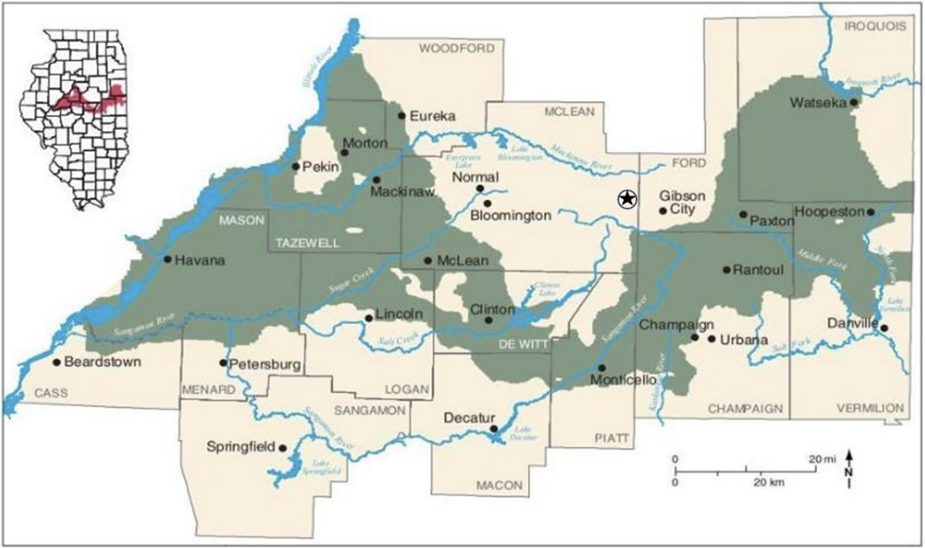
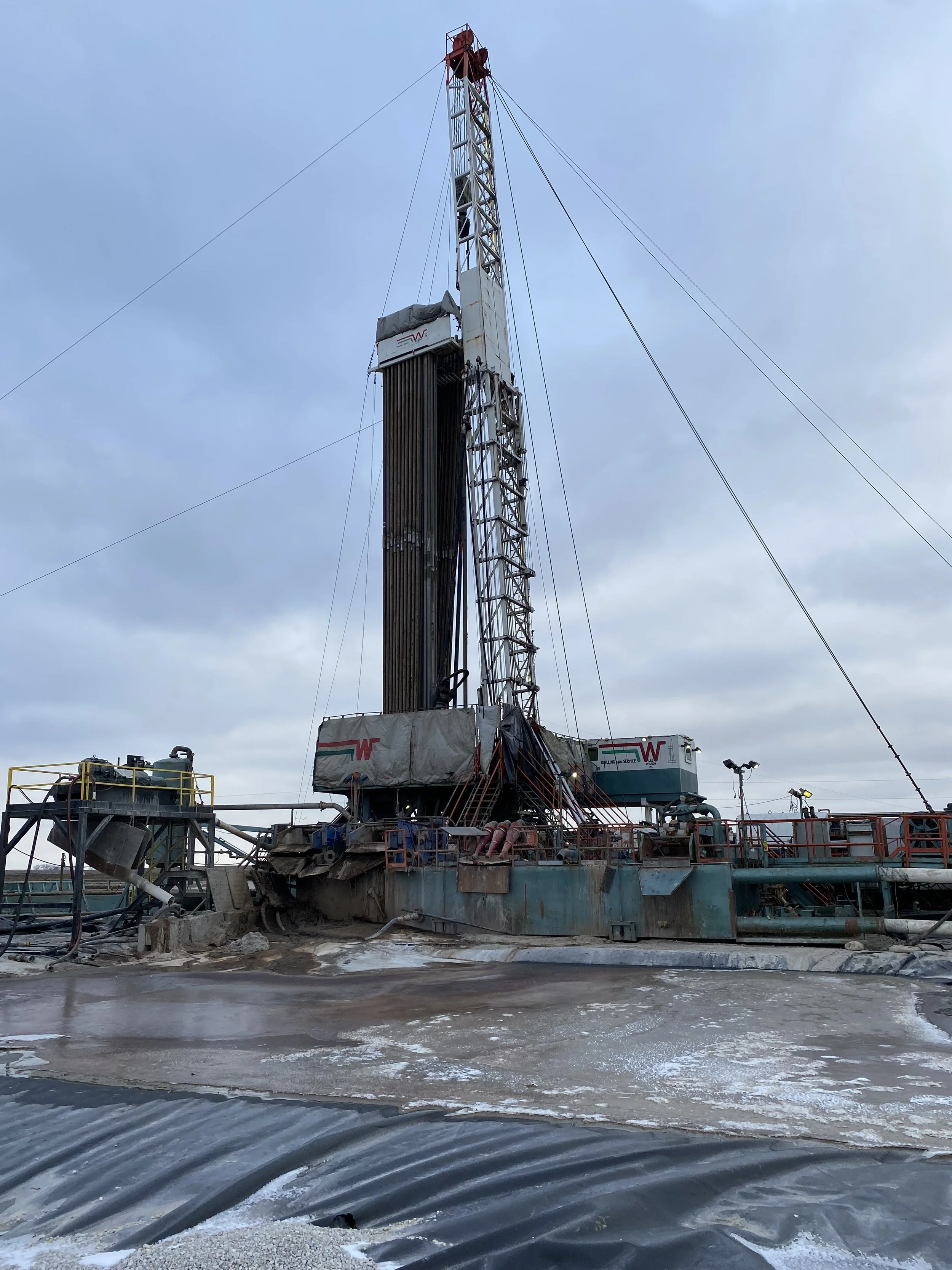
OEE #1 Stratigraphic Test Well
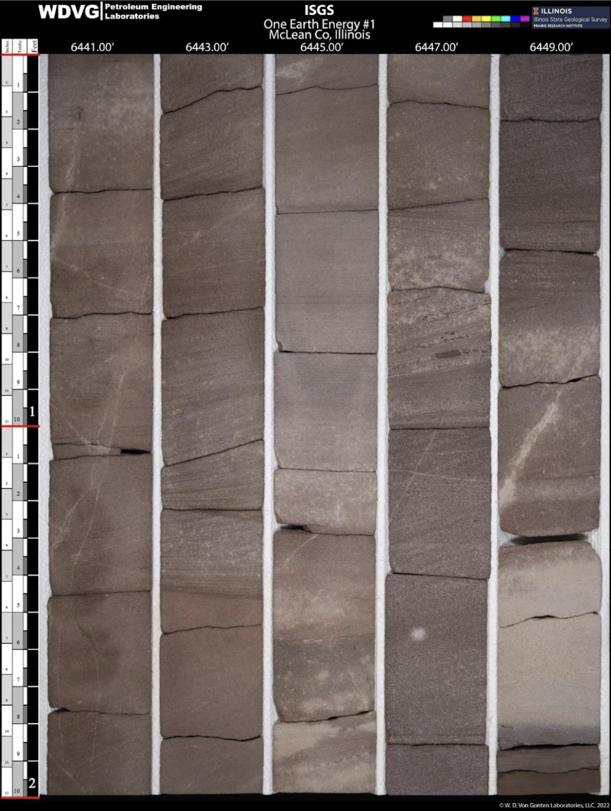
The One Earth Energy #1 (OEE #1) stratigraphic test well was drilled to confirm the deep geologic conditions at the project site and to collect the data needed for the Class VI permit application. The well was permitted by the Illinois Department of Natural Resources and drilled from December 2, 2021, to February 12, 2022, reaching a total depth of 7,104 feet.
Key Geologic Findings
Drilling confirmed the presence of the thick, regionally extensive formations that make up the Mt. Simon–Eau Claire Storage Complex:
The Mt. Simon Sandstone begins at 4,455 feet and is 2,014 feet thick
The Arkose interval, the target injection zone, begins at 6,262 feet and is 207 feet thick
The overlying confining layers are thick, continuous, and naturally suited to keep CO₂ deep underground
These results show that the site has the geologic characteristics needed for safe, permanent CO₂ storage.
Data Collected
The well provided a comprehensive set of measurements used to understand the subsurface:
Geophysical wireline logs
64 rotary sidewall cores
252 feet of whole core
A fiber‑optic cable installed from 4,400 feet to the surface for continuous temperature and acoustic monitoring
This information helps describe how the rock layers behave and how they will safely contain CO₂.
Well Testing
A series of well tests were performed to measure formation pressure, fluid properties, and how easily fluids move through the rock. These tests help confirm that the target injection zone can accept CO₂ at the project’s proposed rates and that the overlying layers act as effective natural barriers.
Vertical Seismic Profile (VSP)
A vertical seismic profile was collected in OEE #1 to create a clearer picture of the rock layers around the well. The VSP helps tie the well data to regional seismic surveys and confirms the depth, thickness, and continuity of the storage and confining formations.
Geologic Modeling
All data from OEE #1 — including cores, logs, well tests, and the VSP — were incorporated into a three‑dimensional geologic model. This model helps evaluate how CO₂ will behave in the Mt. Simon Sandstone under the project’s proposed injection conditions and supports the Class VI permit application.
Future Use as a Monitoring Well
After the Class VI permit is approved, OEE #1 will be converted into a monitoring well. It will be used to:
Sample formation fluids
Measure pressure changes
Track temperature and acoustic signals through the fiber‑optic system
Confirm the location and movement of the CO₂ plume using pressure, fluid, and seismic monitoring tools
What the Class VI Permit Application Includes
The Class VI permit application contains several major components that describe how the project will be designed, constructed, operated, and monitored. These include:
Geologic site characterization – information about the deep rock layers that will store CO₂
Well construction and testing plans – how the injection and monitoring wells will be built and evaluated
Monitoring program – how pressure, fluids, and the CO₂ plume will be tracked over time
Area of Review (AoR) evaluation – how the project ensures protection of underground sources of drinking water
Corrective action and emergency response plans – procedures for safe operations and rapid response
Long‑term site care – how the site will be monitored after injection stops
Financial assurance – documentation that the project has the resources to safely operate, monitor, and close the site in accordance with EPA requirements
CLASS VI PERMIT APPLICATION STATUS
The OES Class VI permit application is under review by the U.S. Environmental Protection Agency’s Underground Injection Control (UIC) Program.
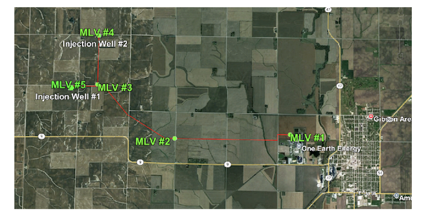
Proposed CO₂ Pipeline Route
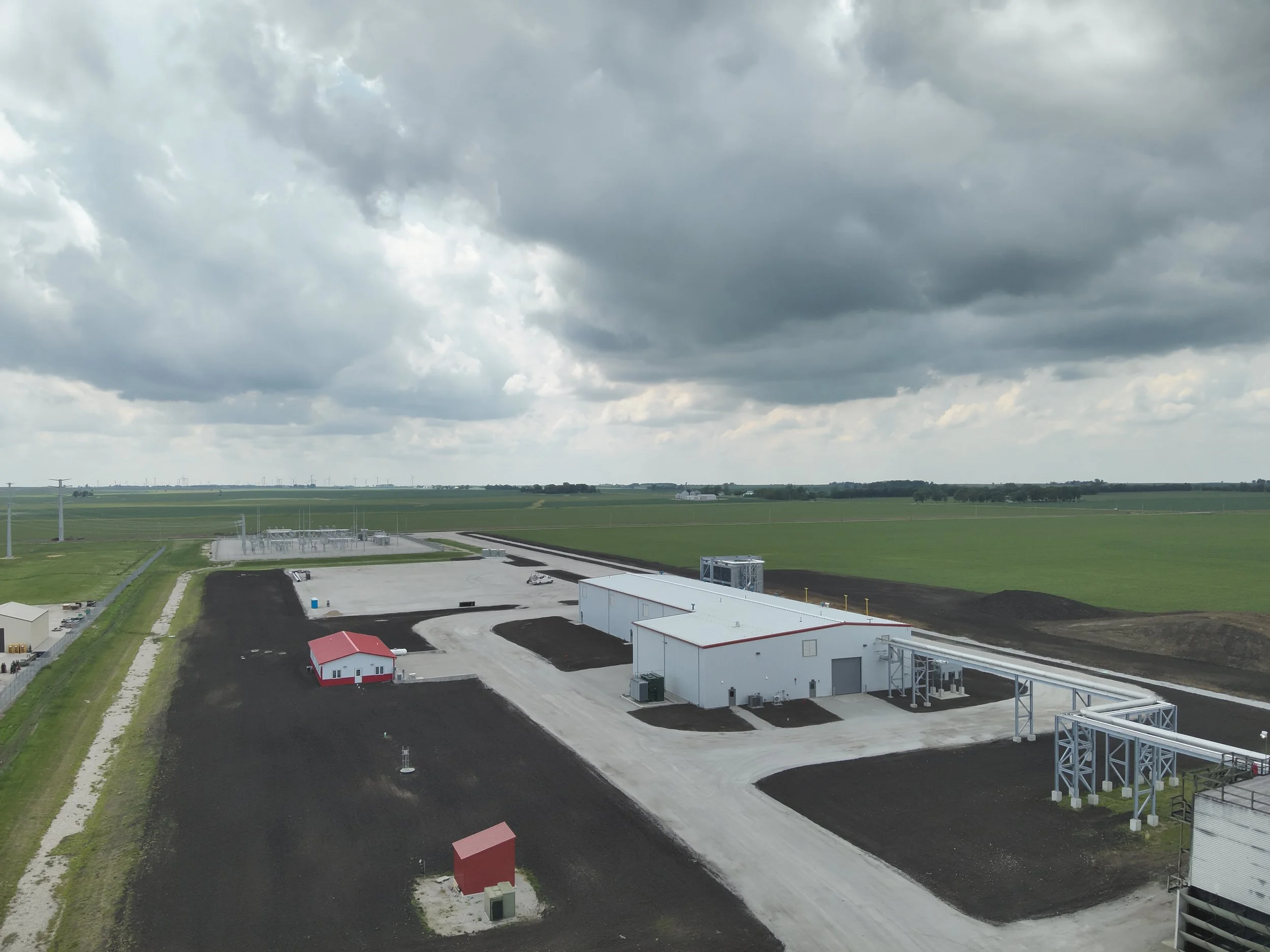
OES has completed extensive work to design the carbon capture and sequestration system. The CO₂ compression facility is already constructed, and engineering and safety planning for the transportation pipeline is ongoing.
State law currently pauses new carbon pipeline approvals under the SAFE CCS Act until July 2026, or until updated federal safety rules are issued by the Pipeline and Hazardous Materials Safety Administration (PHMSA). OES will continue advancing planning and design work during this period.
Pipeline Overview
Approximately 5.92 miles in length
Begins at the existing CO₂ compression facility in western Ford County
Crosses into McLean County
Terminates at the proposed injection well sites
No eminent domain was used — all landowner agreements were secured voluntarily
This planned route follows existing transportation corridors where possible and reflects extensive coordination with landowners, local officials, and state agencies